The history of human shelter in the Neepawa area began almost 12,000 years ago, when the earliest people arrived soon after the last Ice Age glaciers had melted away. Until the appearance of European traders and explorers in the eighteenth century, the area was occupied by five hundred generations of hunters and gatherers whose seasonal movements were governed by the availability of various plants and animals.
Their history is a testimony to human adaptation and innovation. For example, over 5000 years ago they learned the secret of how to fashion finely wrought tools of copper, making them among the earliest metallurgist in the world. By the beginning of the Christian Era, the introduction of the bow and arrow revolutionized hunting. Another innovation was the “pound” – a sort of corral or trap into which large numbers of bison were stampeded and killed. The need for mobility had a direct bearing on most aspects of the lives of these people; it was necessary to be in the right place at the right time to harvest various wild plants as well as to intercept the migratory bison that formed the basis of their livelihood. The tipi – a conical wooden frame covered with hides – provided them with a durable shelter which could easily be transported.
When Europeans first arrived in the Neepawa district, they found it to be occupied by Assiniboine and Cree. Scattered bands of people followed a fairly regular seasonal cycle that often brought them into contact with one another. This was especially true in the winter when both bison and people sought shelter in wooded valleys and where firewood was readily at hand. In spring, after the choking river ice had melted, the people dispersed to set their fishing weirs along local waterways. At the same time, raiding parties were sent against other tribes to the south and west. During summer, villages were in an almost constant state of movement, accompanying the parties of hunters that roamed the open grasslands in search of bison. And in autumn, whole communities undertook the annual trek to the south – to the villages along the Missouri River where the proceeds of the hunt and European trade goods could be exchanged for corn.
The considerable mobility of the local Native populations throughout the past resulted in their having left behind no standing buildings or structures. The tipi was not designed to be a permanent edifice, and the materials of which it was made were perishable. The “foundations” of the tipis – circles of rock that held down the edges – are easily disturbed and scattered by cultivation practices. This has no doubt been the fate of many such features in the Neepawa area, which has been intensively cultivated over the past century.
Most of the early southern Ontario settlers seeking farming opportunities west of Lake Manitoba and south of what is today Riding Mountain National Park, made their way along the North Fort Ellice Trail, a well-travelled route linking Red River and Fort Edmonton. Struggling along this trail in mid-July of 1877, a group of thirty settlers from Listowel, Ontario reached Palestine (now Gladstone), Manitoba, camped near the Arden Ridge and then stopped at Millar’s Halfway House, about five kilometers west of Arden. While some members of the group decided to homestead in the vicinity, the 14-member Graham family continued on to the Whitemud district – to what is now the Town of Neepawa. Selecting a high, well-drained plateau, which is today Riverside Cemetery – overlooking the valley where the Stony and Boggy creeks join to form the Whitemud River – the Grahams became the first settlers of Neepawa.
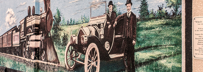
The story of the establishment of the Town of Neepawa itself is a familiar one. Relying as it so often does on decisions made by the burgeoning railway companies, the story is nevertheless usually an interesting one – in Neepawa, it is certainly so. In 1880, two former Palestine businessmen, John A. Davidson and Jonathon J. Hamilton, arrived at the settlement, purchased land and surveyed town lots. They also established a general store just south of the Graham family homestead. However, when the construction of the Canadian Pacific Railway (CPR) mainline past Portage la Prairie commenced in 1880, rumour quickly spread that a station was to be located at Spring Creek, southwest of Neepawa. Sensing a grand opportunity – for a railway station virtually ensured the development of a community – Davidson and Hamilton planned to open a story in Spring Creek. In 1881, however, the route swung south of Spring Creek to DeWinton (now Carberry) dashing any hopes for a new town.
Disappointed but undeterred, Davidson and Hamilton turned their attention back to Neepawa and the Manitoba and Northwestern Railway (M & NW, later leased by the CPR). This rail line had reached Gladstone by 1882 and the company was planning to extend the line further west. Davidson and Hamilton owned land near the Graham homestead where the proposed M & NW line was to be built. Here, they were convinced; they had finally made a secure investment. But luck and the partners’ dreams resisted association. The M & NW announced its plan to pass three kilometers north of Neepawa! Still determined but by now likely weary of second guessing the railway companies, Davidson, Hamilton, and a group of villagers offered the M & NW the incentive of a land grant and a financial bonus of $16,000 to construct their line within the town limits. The railway was persuaded, as these companies were so often persuaded throughout the West, and Davidson and Hamilton finally obtained their railway. The community was incorporated in 1883 and was named Neepawa, a Cree word for “plenty” or “abundance”.
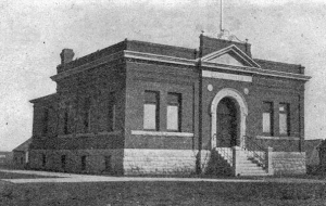
Postcard view of Neepawa Land Titles Office (no date) Source: Gordon Goldsborough, 2012-0104
After the flurry of excitement accompanying the arrival of the railway and the community’s incorporation, the townspeople soon realized that a competitive situation had been created between the north and south ends of the town with the placement of the M & NW Railway. The track and depot were built just within the northern limits of the town, almost a kilometer from Davidson’s and Hamilton’s dry goods business. (They must have felt truly jinxed.) The result was the development of two rival commercial districts – the North End or “Old Town”, centered on Railway Street, and the South End, situated in the vicinity of Hamilton Street and Mountain Avenue.
A variety of businesses quickly emerged along the north side of Railway Street adjacent to the M & NW line. Commercial success seemed assured for businesses like the Beautiful Plains Milling Company, the Wakefield and Killington Planning Mill, the John Crawford Implement Company and Hartford’s General Store which all flourished in the North End. The Klondike Hotel, Simpson Hotel and the Birch Boarding House, also in the North End, provided needed accommodation for visitors, travelers and the growing itinerant labor force arriving in Neepawa.
But the favorable position enjoyed by the North End was short-lived. Changes in the town’s building code, sensitive to the threat of fire, required brick rather than wood as a construction material. In time, older wood-frame structures built in the North End were either abandoned or occasionally replaced with brick buildings. Businesses gradually began to move south down Mountain Avenue from the tracks. Grain elevators and milling companies built near the M & NW also suffered economically as the railway company began investing other nearby communities with grain-handling facilities as well.

A.F. Mackenzie – “A Brief History of Neepawa – Land of Plenty” 1958
Gradually the South End began to surpass the commercial activity along Railway Street. The earliest business center of Neepawa had been located on Hamilton Street, just east of Brown Avenue. And now that the South End was regaining it’s dominance, that specific area reasserted its economic influence. However, the construction of the Davidson Block in 1889 on the northwest corner of Hamilton Street and Mountain Avenue precipitated a westward shift in the establishment of business enterprises. With the construction in 1902 of a second rail line, by the Canadian Northern Railway (CNoR), later the Canadian National Railway, on Hamilton Street West, the South End emerged as the commercial heart of Neepawa, as it remains today.
The rivalry between the North and South Ends for commercial supremacy did not affect Neepawa’s actual growth as a community. And while development of the town was slower than that of Portage la Prairie and Brandon, whose early years were marked by a period of rapid growth, it was nevertheless steady. When the Town of Neepawa was incorporated on 3 November 1883 its population totaled 308. Some forty years later, in 1921, the population had risen to 1,864; today it is approximately 3,425. The community became a strong one, its success ground chiefly in its importance as a railway hub and as a trading center reliant on the wheat economy. Other small local industries, such as lumber milling, farm equipment manufacturing, dairy goods production and eventually brick plants added greatly to the town’s industrial diversity. By 1896, an assortment of commercial and professional businesses and societies were active in Neepawa, including 2 banks, 3 hotels, 3 boarding houses, 7 fraternal societies, 4 real estate agents, 2 veterinarians, 1 dentist, 3 physicians, a daily newspaper and a telephone exchange with 50 subscribers.
Neepawa is located in Treat 2 Territory.
Taken from NEEPAWA – An Architectural Walking Tour